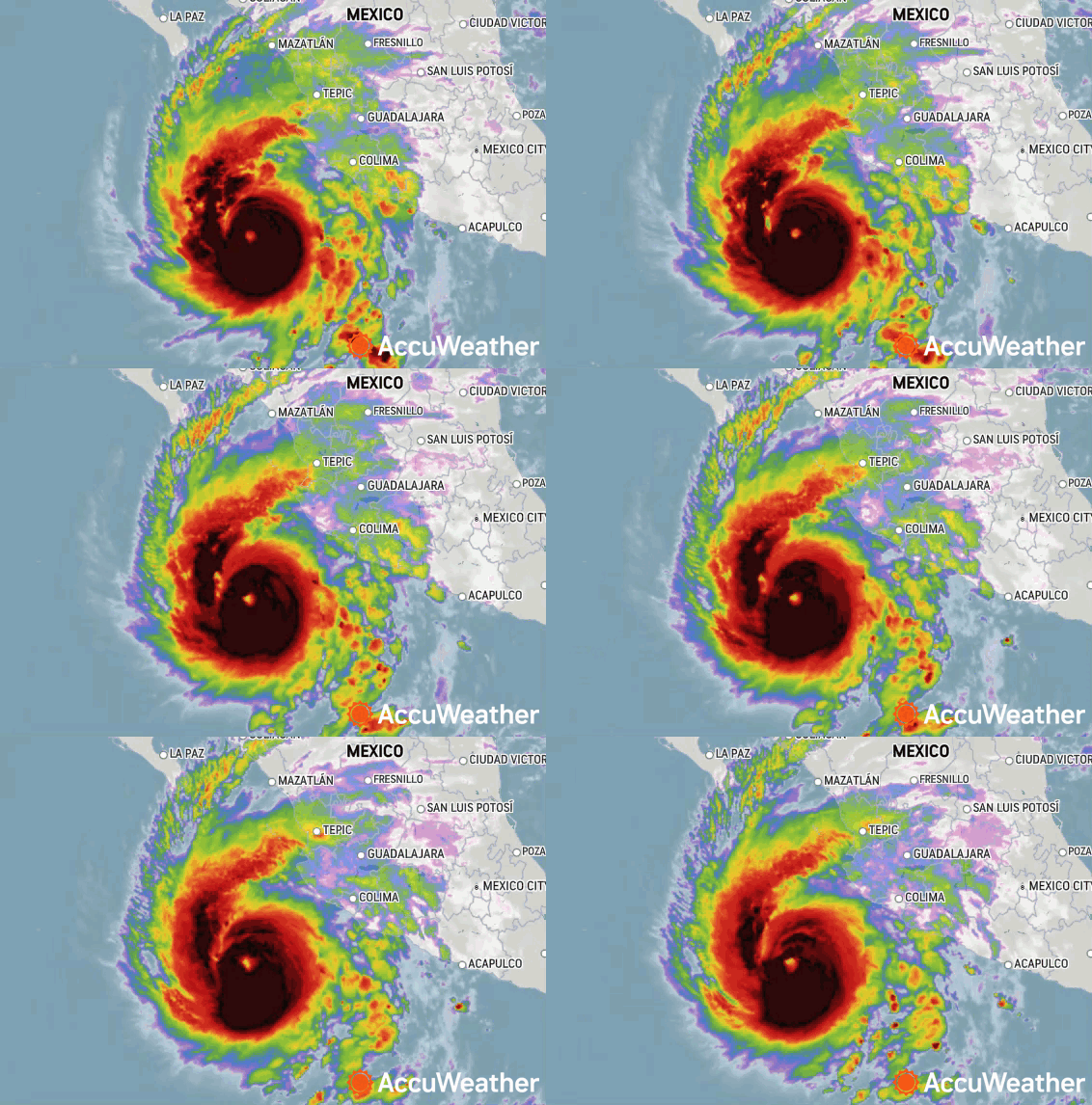
Hurricane Norma rapidly intensified into a major hurricane over the East Pacific on Wednesday into Thursday morning, as predicted by AccuWeather meteorologists.
Some additional strengthening is possible before it begins to lose some wind intensity. Still, AccuWeather forecasters warn that life-threatening conditions could unfold as the powerful hurricane inches closer to Mexico, and some of Norma’s moisture could eventually help to fuel an outbreak of drenching rain in part of the drought-stricken central United States next week. Advertisement
The Category 4 hurricane had maximum sustained winds of 130 mph as of Thursday morning as it was swirling 410 miles south-southeast of Cabo San Lucas, located at the southern tip of the Baja California Peninsula of Mexico. Norma was crawling northward at 7 mph.
|
|
| Hurricane Norma on infrared satellite late Thursday morning. |
Advertisement
Norma is not expected to make landfall in Mexico as a major hurricane as the last tropical system to hit the country did just weeks ago. Major Hurricane Lidia struck Mexico as a Category 4 hurricane on the Saffir-Simpson Hurricane Wind Scale just to the south of Puerto Vallarta. It had maximum sustained winds of 140 mph as it crashed ashore on Oct. 10.
“Norma will begin to lose wind intensity late this week and this weekend as it encounters cooler waters,” AccuWeather tropical meteorologist Alex DaSilva said.
|
|
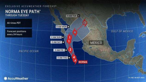
The path and intensity of Norma in the short term is the most certain, DaSilva explained.
“Steering breezes will guide Norma on a general north-to-northwest path into this weekend,” DaSilva said. “The hurricane will approach the southern tip of the Baja Peninsula of Mexico on Sunday or perhaps as early as Saturday night.”
The guiding forces of Norma this weekend into next week will be a bit more complex and largely dictated by non-tropical weather features. AccuWeather senior meteorologist Joe Lundberg said a big player will be the position of the jet stream over the western United States this weekend to next week.
“If that jet stream dips far enough to the south, it will pick up Norma and fling it swiftly northeastward and into the interior Southwest and southern Plains of the U.S. next week,” Lundberg said. “But, if that jet stream dip is more shallow, Norma could miss the tug and may hover near the coast of Mexico much of next week while slowly diminishing over churned-up cooler waters.”
|
|
Advertisement
It’s really a wait-and-see situation, Lundberg added. AccuWeather meteorologists will watch the jet stream’s behavior over the western United States this weekend to determine Norma’s next move.
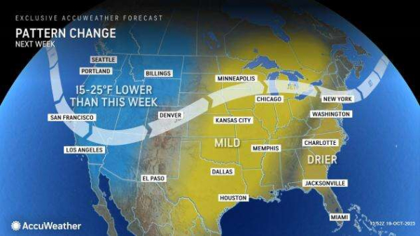
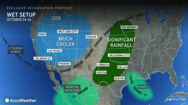
The plunging jet stream in the western United States will also be responsible for a significant pattern change across the region. Much cooler air will replace the record heat that has been searing the Southwest, and the first wind-blown snow event could unfold across parts of the northern Rockies and High Plains.
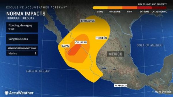
Even if Norma moves to the northeast across northern Mexico early next week and into the United States during the middle of next week, much of the tropical system’s moisture will be wrung out over the coastal areas as a tropical storm or hurricane and then the interior mountains of northern Mexico as a tropical rainstorm.
|
|
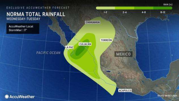
Heavy rain is likely and could lead to incidents of life-threatening flash flooding, mudslides and washouts even though the system will lose wind intensity before reaching the southern part of the Baja Peninsula and along the west-central coast of mainland Mexico.
|
|
Powerful winds generated by the major hurricane will raise massive seas in the region. These waves will continue even as the hurricane loses wind intensity. Forecasters urge beachgoers, fishing and cruise interests to heed all warnings as conditions will turn dangerous. Large waves will crash ashore and may cause flooding and other damage along the coast. Sudden large waves could sweep onlookers out to sea. Advertisement
Regardless of Norma’s path, some rain is coming to parts of the South Central states next week.
“There should be enough of a jet stream dip to help pull some Gulf of Mexico moisture northward,” Lundberg said. “But, how dynamic that is will depend on the jet stream dip intensity and whether or not some of Norma’s moisture and energy are also involved.”
|
|
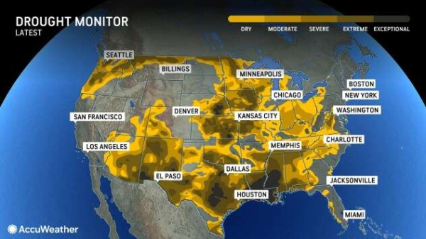
Any rain over the Central states would be welcomed due to long-lasting and far-reaching drought conditions.
The drought has been so significant that it has been producing record-low levels on the Mississippi River, which in turn has resulted in a severe reduction in the transport of goods on the waterway and the intrusion of salt water into the drinking supply in southern Louisiana.
|
|
Since most of the rain is likely to be spread out over many hours, even where rainfall exceeds 4 inches, the dry ground tends to absorb the water rather than go directly into filling streams and progressively larger rivers.
However, there are likely to be pockets where intense rain falls in a few hours and runs off rapidly due to hard-packed soil or rocky soil conditions. This flash flood potential is most likely in parts of Texas, Oklahoma and perhaps New Mexico should the swath of rain develop farther to the west. Advertisement
