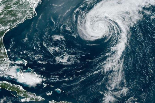
1 of 2 | Ernesto struck Bermuda as a Category 1 storm Saturday morning. Image courtesy of the National Oceanic and Atmospheric Administration
Tropical Storm Ernesto is headed to Canada on Sunday one day after striking Bermuda as a Category 1 hurricane and with “dangerous beach conditions” along the U.S. East Coast through early this week, according to the National Hurricane Center.
“Beachgoers should be aware that there is a significant risk of life-threatening surf and rip currents, and should stay out of the water if advised by lifeguards,” NHC forecaster Robbie Berg said. Advertisement
More than 630,00 million people were under high surf advisories and more than 10.2 million people live in rip currents situations, according to the National Weather Service.
“Up to one half foot of inundation above ground level expected in vulnerable areas near the waterfront and shoreline,” NWS in New York said in a hazard message.
In New York City, ocean-facing beaches were closed for swimming in Brooklyn and Queens on Saturday and Sunday. That includes Coney Island. Advertisement
Ernesto was forecast to strengthen on Sunday and move into Canada by Monday.
Accuweather.com forecasts Ernesto to impact the British Isles from Wednesday night to Thursday.
“As Ernesto moves along, it will be of concern for ships at sea over the North Atlantic from Tuesday to Wednesday,” Accuweather.com forecaster Alex Sosnowski said. “The storm will accelerate and may reach forward speeds of 30-40 mph. Seas ahead of the storm will quickly build to 20-30 feet.”
Ernesto became a hurricane with maximum sustained winds of 85 mph as it passed over Bermuda.
In the 5 a.m. EDT report, NHC said sustained winds were 70 mph and Ernest was moving north-northeast at 9 mph, about 690 miles south of Halifax, Nova Scotia and 980 miles southwest of Cape Race, Newfoundland, Canada. Bermuda Weather Service discontinued a tropical storm warning.
Ernesto lacks a “well-defined eye feature,” NHC forecaster Richard Pasch. It may strengthen back into a hurricane by Monday morning.
On the forecast track, the center of Ernesto to pass near southeastern Newfoundland, Canada, mostly likely as a post-tropical storm Monday night.
For the next two days, life-threatening surf and rip current conditions are likely for the Bahamas, Bermuda, the East Coast of the United States and Atlantic Canada, NHC said. Advertisement
Bermuda Premier David Burt said Saturday night “there are a significant number of people without power, and anyone on the roads will impede the progress of the restoration of the power efforts and also the restoration of the roads and clearing of roads which may be blocked.”
A total of 14,073 customers were without power among the island’s 64,626 residents.
No major damage in Bermuda has been reported.
The storm strengthened into a hurricane Wednesday, continued intensifying throughout Thursday and hit Category 2 status Thursday night with sustained winds of 100 mph.
Ernesto’s center never made landfall over Puerto Rico or the U.S. Virgin Islands it knocked out power to hundreds of thousands of customers. On Saturday afternoon, 6,351 remained without power on U.S. Virgin Islands, according to Poweroutages.us.
Heavy rain soaked the Virgin Islands on Tuesday and Wednesday.
Debby was a Category 1 storm that made landfall in the Florida Panhandle and then moved through the U.S. Atlantic Coast last week causing torrential rain and widespread, record flooding up the eastern seaboard.
Beryl struck parts of the Caribbean, the Yucatán Peninsula and the Gulf Coast of the United States in late June and early July. Advertisement
Two tropical storms were in the Gulf of Mexico in June: Cindy and Alberto.